Drone LIDAR/Imagery Sensor Fusion, by Design
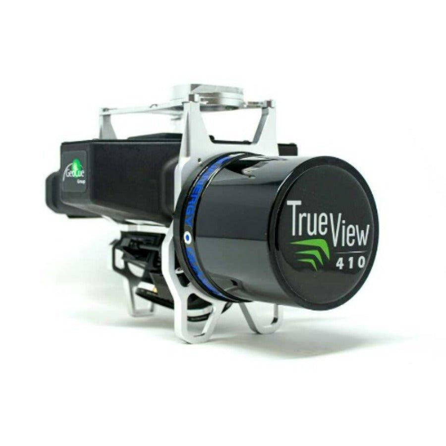
True View® 410
The True View® 410 is the industry’s first integrated LIDAR/camera fusion platform designed from the ground up to generate high accuracy 3D colorized LIDAR point clouds. Featuring dual GeoCue Mapping Cameras, a Quanergy M8 Ultra laser scanner and Applanix Position and Orientation System (POS), the result is a true 3D imaging sensor (3DIS). With its wide 120° fused field of view, the True View 410 provides high efficiency 3D color mapping with vegetation penetration in a payload package of 2.2 kg.
Dual Cameras
Two GeoCue Mapping Cameras provide a 120° field of view, coincident with the laser scanner track. The 25° oblique mounting ensures the sides of objects are imaged, allowing a true 3D colorization of all LIDAR points.
LIDAR Scanner
Two GeoCue Mapping Cameras provide a 120° field of view, coincident with the laser scanner track. The 25° oblique mounting ensures the sides of objects are imaged, allowing a true 3D colorization of all LIDAR points.
Google Processor
A Google® Coral TensorFlow Processing Unit provides exceptional power as the True View central controller. The CCU coordinates all on-board functions of the system.
Applanix Positioning
A sensor can be no more accurate than the position and orientation system. GeoCue incorporates the industry’s most accurate and reliable POS – the Applanix APX series. APX post-processing is accessed via the included True View software, providing “pay-as-you-go” access to SmartBase and Trimble PP-RTX positioning services.
True Track® Flightlines
Post-processing software uses positioning system information to perform roll compensation at the individual scan line level. This allows reduced overlap between flight lines, increasing platform flight efficiency.
True Time Synchronization
Fusing sensor data requires exceptional timing synchronization among the positioning system and all sensors. True View’s System Synchronization Unit (a GeoCue designed Master Clock), ensures sensor coordination at the microsecond level.
True View EVO: Complete Workflow Software
GeoCue’s True View EVO software, bundled with every system, provides a complete post-processing workflow solution from project creation through final products.
Assess and Report Your LIDAR Data
Assessing, correcting and reporting geometric accuracy is critical to metric mapping workflows. True View EVO processing software contains tools to assess/report network accuracy according to American Society for Photogrammetry and Remote Sensing (ASPRS) standards, measure hard surface precision and geometrically adjust LIDAR data.
More Info
What's Included
Specifications
True View 410 Product Specifications
- LIDAR Scanner Quanergy M8
- UltraLIDAR Range – Usable 75m
- Cross-track Field of View (FOV) – usable 90°
- LIDAR Beams/Returns 8/3
- Pulse Repetition Rate 420 kHz
- Accuracy Better than 5 cm RMSE
- PrecisionBetter than 5 cm at 1 σ
- Dual Cameras (Port, Starboard) ±25° cross-track oblique
- Camera Sensor 1’’ mechanical shutter, hardware mid-exposure pulse, 20 MP, RGB
- Camera Lens28 mm ƒ, 2.8 Max F Stop, fixed focus
- Camera Cross-track FOV120°, total
- Camera Trigger Interval or Distance
- Mass 2.25 kg
- Operating Time (per battery) ~ 1.5 hours
- Dimensions12.5” x 6.5” x 7”